In the Park
Alberta Falls is the easy win in Glacier Gorge: a short walk through aspen and pine to a waterfall that's loud in early summer. It's popular for good reason, and the trail keeps going if you've got more in you.
8.0 mi from downtown
In the Park
A big granite boulder perched on a much smaller stone at the north end of Lumpy Ridge. It's a long walk to see a rock, but the boulders you pass on the way, some with holes clear through them, are half the fun.
2.3 mi from downtown
In the Park
Bear Lake is the busiest spot in the park for a reason: a short loop, a mountain behind it, and the trailhead for half the lakes people come to see. Treat it as a launch pad, and get there early.
8.0 mi from downtown
In the Park
Bear Lake is the starting line for half the big hikes in the Park, and the lot knows it. The loop around the water is short and flat, and it's a good first hour of a high country day.
Open now · open 24 hours7.9 mi from downtown
In the Park
Bierstadt Lake is a forest lake on a bench above Bear Lake Road, circled by a trail. Getting there is a steady climb, which keeps the crowds thinner than at the lakes farther up the road.
6.5 mi from downtown
In the Park
This is the short, steep way up to Bierstadt Lake, with switchbacks that climb a moraine above Bear Lake Road before the trail flattens out into aspen and a quiet lake. I'd rather come down these switchbacks than up them.
6.7 mi from downtown
In the Park
Think of the Bierstadt Moraine Trail as a connector, a mostly level walk through aspen and pine above Bear Lake Road. It's not a destination on its own.
5.4 mi from downtown
In the Park
Chasm Junction is a fork in the Longs Peak trail at about 11,500 feet, just above treeline. One way goes toward the Keyhole Route, the other to Chasm Lake.
8.6 mi from downtown
In the Park
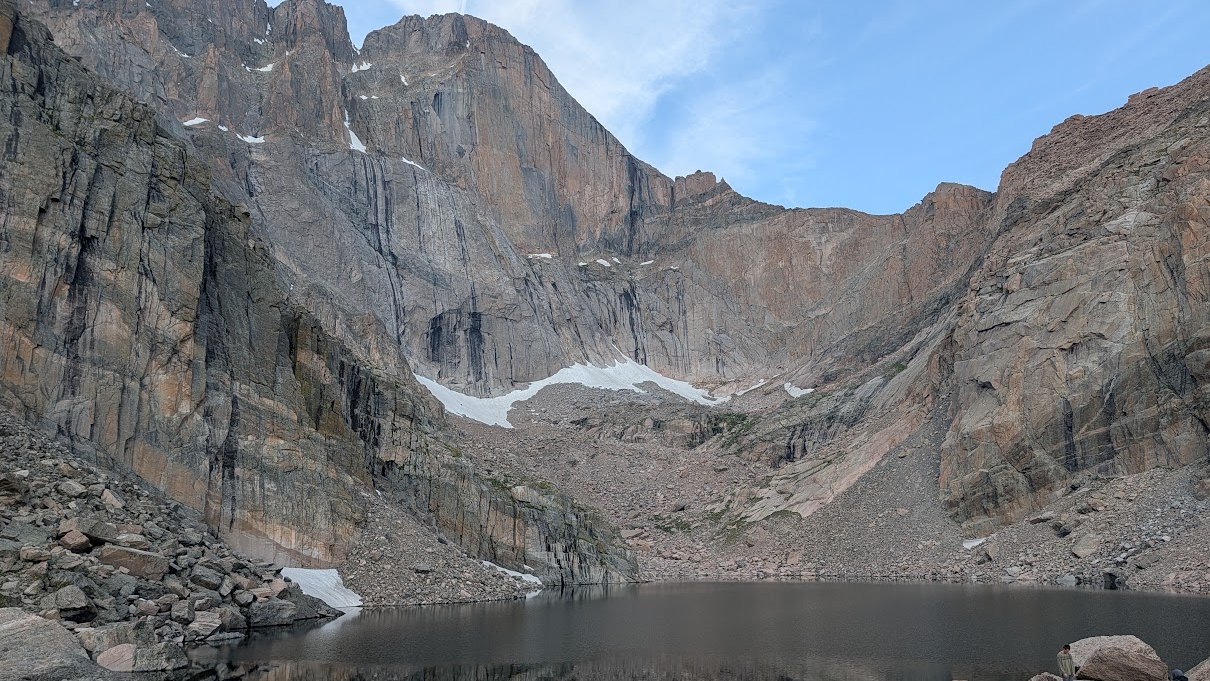
Chasm Lake sits in a cirque under the east face of Longs Peak, at the end of a hard, high hike. It's the big-day lake, and it's worth every foot if you start early and the weather holds.
9.3 mi from downtown
In the Park
Cow Creek is the north side trailhead most visitors never find, out at the old McGraw Ranch at the end of a dirt road. When Bear Lake is a parking lot, this is where I'd point you.
3.9 mi from downtown
In the Park
Cub Lake is a Moraine Park classic, a walk out of the big glacier-carved meadow and up to a quiet lake. It's a moderate hike, and if you start early, you'll have a good share of it to yourself.
6.8 mi from downtown
In the Park
Cub Lake is one of the best walks in Moraine Park, a meadow stroll that climbs into forest and ends at a lake ringed with dead trees from the 2012 Fern Lake Fire. Fall is when I'd go, for elk and gold aspen, and moose are always a possibility.
Open now · open 24 hours5.2 mi from downtown
In the Park
Deer Mountain is the summit I send friends to when they want a real peak without a punishing day. It starts high, at Deer Ridge Junction, and it gives you wide views without much drama.
Open now · open 24 hours4.7 mi from downtown
In the Park
Dream Lake is the second stop up the trail from Bear Lake, with steep cliffs on the far shore. It's a short climb past Nymph Lake and the view repays it.
8.6 mi from downtown
In the Park
This is the east parking area for the Alluvial Fan, up Endovalley Road in Horseshoe Park. It's where you go to see what one broken dam did to a mountain valley.
6.3 mi from downtown
In the Park
East Portal is the quiet back door into the Park from the south side of town, at the end of Highway 66 near the YMCA. Fewer tour buses, more forest.
4.5 mi from downtown
In the Park
Emerald Lake is the end of the line on the Bear Lake trail, a bigger effort than Dream Lake and the one I'd pick if you've got half a day. Go early, take the shuttle, and bring a jacket.
9.0 mi from downtown
In the Park
Fall River runs through Horseshoe Park, the wide, flat meadow just inside the Fall River Entrance. It's an easy place to watch water do what water does in the mountains, and the start of Old Fall River Road.
6.4 mi from downtown
In the Park
Fern Lake sits at the end of a long, steady climb up the Big Thompson canyon, with a quiet backcountry campsite on its north shore. It's the one I'd pick when Bear Lake looks like a parking lot sale.
8.6 mi from downtown
In the Park
Fern Lake is a good one for people who want a long day in the woods with water along the way. The trailhead is at the end of Moraine Park.
Open now · open 24 hours6.0 mi from downtown
In the Park
Gem Lake is a small, rocky lake you earn with a steep, sunny climb up from Lumpy Ridge. It's short on miles and long on stairs.
2.5 mi from downtown
In the Park
Glacier Gorge Junction is the jumping-off point for Alberta Falls, Mills Lake and a whole run of lakes beyond. It's busy and it deserves to be.
7.8 mi from downtown
In the Park
The parking lot for Rocky Mountain National Park's only sledding hill. Winter is the point.
Open now · open 24 hours7.1 mi from downtown
In the Park
Hollowell Park is a quiet pullout on Bear Lake Road with meadow, creek and mountain views, and a route into Mill Creek Basin. It's less famous than its neighbors.
5.0 mi from downtown
In the Park
Lake Haiyaha is a rocky, moderate hike from Bear Lake to a lake that feels a long way from the paved crowd. The last stretch is rough footing.
8.9 mi from downtown
In the Park
Lawn Lake is a long day hike up the Roaring River drainage, and it has a story. The dam here failed in 1982 and rearranged the valley below.
8.4 mi from downtown
In the Park
Lawn Lake is a long, honest climb out of Horseshoe Park. It's a big day and I wouldn't hand it to a first-timer.
5.9 mi from downtown
In the Park
Lily Lake is the easy one. A flat, accessible loop on Highway 7 with Longs Peak hanging over the water, and none of the Bear Lake Road scramble.
Open now · open 24 hours4.9 mi from downtown
In the Park
This is the fork about two miles up the Glacier Gorge trail where you have to choose. Mills Lake is to the left, The Loch is straight ahead, and Lake Haiyaha is to the right.
8.6 mi from downtown
In the Park
The Keyhole Route is the standard way up Longs Peak, and the Park calls it a climb, not a hike. It's about 15 miles round trip to 14,259 feet, and the day starts in the dark.
8.3 mi from downtown
In the Park
Every Longs Peak day starts here, usually in the dark. It's a small lot off Highway 7 south of Estes Park, and the trail heads straight up into the trees.
7.5 mi from downtown
In the Park
Many Parks Curve is a hairpin pullout on Trail Ridge Road where the mountains open up and you can see the meadows laid out below. Park, step out, take your time.
Open now · open 24 hours5.9 mi from downtown
In the Park
Mills Lake is the big payoff in Glacier Gorge: a subalpine lake with mountains all around it and a waterfall on the way in. It's a real hike, not a stroll, but it's the one I send friends on when they want the full Rocky Mountain picture.
Open now · open 24 hours8.7 mi from downtown
In the Park
Past Mills Lake the crowd thins out and the trail gets rougher. Black Lake sits at the head of Glacier Gorge, a bit under five miles from the trailhead.
8.7 mi from downtown
In the Park
A wide, flat valley in Rocky Mountain National Park that glaciers carved out, with the Big Thompson River looping through it. Elk graze here and people stop their cars in the road to look.
4.3 mi from downtown
In the Park
This is the Fall River Visitor Center, the Park's welcome mat on the Highway 34 side. Stop here before you drive in.
5.5 mi from downtown
In the Park
Nymph Lake is the first lake on the Bear Lake climb, and most people march right past it toward Dream. Don't.
8.3 mi from downtown
In the Park
Odessa Lake sits a mile past Fern Lake, and you earn it. It's a big day on a long trail, and the quiet at the end is the whole point.
9.2 mi from downtown
In the Park
Sheep Lakes is a glacier-carved meadow in Horseshoe Park where bighorn sheep come down off the mountains to lick mud for minerals. If you want a wildlife stop that doesn't need a boot or a backpack, this is it, but it works best when you are patient.
5.6 mi from downtown
In the Park
Sprague Lake is the easy one. It's a flat loop under a mile around a lake with the Continental Divide behind it, and the boardwalk works for wheelchairs and strollers.
Open now · open 24 hours6.0 mi from downtown
In the Park
Spruce Lake is the side trip off the Fern Lake trail that most people skip, which is exactly why you might want it. It's a long, steady day with a rugged last stretch, and you'll likely have more company from squirrels than hikers.
9.0 mi from downtown
In the Park
The Loch is a mellow lake tucked up Loch Vale, with Taylor Peak and Taylor Glacier filling the head of the valley. It's a longer day than most Bear Lake Road lakes, but the forest walk in is half the reason to go.
9.2 mi from downtown
In the Park
The Pool is where the Big Thompson River meets Spruce and Fern Creeks, a wide spot in the water that people were stopping at long before the Park existed. It's an easy-ish first stretch of the Fern Lake trail and a good turnaround if you don't want the full day.
7.5 mi from downtown
In the Park
Tuxedo Park is a small picnic area inside Rocky Mountain National Park on Bear Lake Road, with tables beside a stream. It's easy to miss, and quiet compared to the big lots up the road.
4.0 mi from downtown
In the Park
This is the start of the long trail up to Twin Sisters Peak, off Highway 7 near Lily Lake. It's a real hike, with a rock scramble at the top and views that make the work worth it.
Open now · open 24 hours5.2 mi from downtown
In the Park
Tyndall Creek is the water you hear all the way up the Emerald Lake trail. It comes off the Continental Divide, drops through Dream Lake and Emerald Lake, and keeps you company the whole climb from Bear Lake.
8.8 mi from downtown
In the Park
Upper Beaver Meadows is a quiet valley of meadow and aspen near the Beaver Meadows entrance, with room to spread out. It's where I send friends who want elk and a long view without the Bear Lake crowd.
4.9 mi from downtown
In the Park
Ute Crossing is a small pullout on Trail Ridge Road where the Ute Trail drops onto open alpine tundra. No trees, big sky, and views toward Longs Peak and Moraine Park.
Open now · open 24 hours9.2 mi from downtown
In the Park
The Alluvial Fan is where a dam failure in 1982 tore down the mountain and left a boulder field with water running through it. The short walk here is easy enough for anyone, and the trail is fully accessible.
6.5 mi from downtown
In the Park
The Wind River Trail follows a quiet creek through aspen and pine from East Portal toward Sprague Lake. It's the one I'd point friends to when Bear Lake looks like a parking lot.
5.1 mi from downtown
In the Park
Ypsilon Lake is a long, steep day hike for people who want a real alpine lake and don't mind earning it. It sits under the big shoulder of Mount Ypsilon, and most people never make it this far.
8.8 mi from downtown